 US Dollars
Cartography
Sub Categories

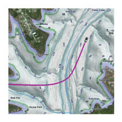
![C-MAP REVEAL X - U.S. Lakes South East [M-NA-T-214-R-MS]](https://cdn11.bigcommerce.com/s-ge8sirtax0/images/stencil/230x230/products/26354/34752/93629XL__54355.1678018216.jpg?c=1 "C-MAP REVEAL X - U.S. Lakes South East [M-NA-T-214-R-MS]")
C-MAP
C-MAP REVEAL X - U.S. Lakes South East [M-NA-T-214-R-MS]
$199.00
REVEAL™ X - U.S. Lakes South EastCOMPATIBILITY WITH SIMRAD NSX SERIES ONLYExperience the X Generation of C-MAP charts - with game-changing Shaded Relief!C-MAP® REVEAL™ X offers a fresh, dynamic experience. All the great features from...
![C-MAP REVEAL X - U.S. Lakes North East [M-NA-T-213-R-MS]](https://cdn11.bigcommerce.com/s-ge8sirtax0/images/stencil/230x230/products/26353/34751/93628XL__66932.1678018214.jpg?c=1 "C-MAP REVEAL X - U.S. Lakes North East [M-NA-T-213-R-MS]")
C-MAP
C-MAP REVEAL X - U.S. Lakes North East [M-NA-T-213-R-MS]
$199.00
REVEAL™ X - U.S. Lakes North EastCOMPATIBILITY WITH SIMRAD NSX SERIES ONLYExperience the X Generation of C-MAP charts - with game-changing Shaded Relief!C-MAP® REVEAL™ X offers a fresh, dynamic experience. All the great features from...
![C-MAP REVEAL X - U.S. Lakes North Central [M-NA-T-212-R-MS]](https://cdn11.bigcommerce.com/s-ge8sirtax0/images/stencil/230x230/products/26352/34750/93627XL__83304.1678018212.jpg?c=1 "C-MAP REVEAL X - U.S. Lakes North Central [M-NA-T-212-R-MS]")
C-MAP
C-MAP REVEAL X - U.S. Lakes North Central [M-NA-T-212-R-MS]
$199.00
REVEAL™ X - U.S. Lakes North CentralCOMPATIBILITY WITH SIMRAD NSX SERIES ONLYExperience the X Generation of C-MAP charts - with game-changing Shaded Relief!C-MAP® REVEAL™ X offers a fresh, dynamic experience. All the great features from...
![C-MAP REVEAL X - U.S. Lakes West [M-NA-T-211-R-MS]](https://cdn11.bigcommerce.com/s-ge8sirtax0/images/stencil/230x230/products/26351/34749/93626XL__46775.1678018209.jpg?c=1 "C-MAP REVEAL X - U.S. Lakes West [M-NA-T-211-R-MS]")
C-MAP
C-MAP REVEAL X - U.S. Lakes West [M-NA-T-211-R-MS]
$199.00
REVEAL™ X - U.S. Lakes WestCOMPATIBILITY WITH SIMRAD NSX SERIES ONLYExperience the X Generation of C-MAP charts - with game-changing Shaded Relief!C-MAP® REVEAL™ X offers a fresh, dynamic experience. All the great features from DISCOVER...
![Garmin Navionics+ NSUS008R U.S. West [010-C1292-20]](https://cdn11.bigcommerce.com/s-ge8sirtax0/images/stencil/230x230/products/25664/33718/92674XL__80931.1678016393.jpg?c=1 "Garmin Navionics+ NSUS008R U.S. West [010-C1292-20]")
Garmin
Garmin Navionics+ NSUS008R U.S. West [010-C1292-20]
$149.99
Garmin Navionics+™ NSUS008R U.S. WestGet the world’s No. 1 choice in the marine mapping (based on 2020 reported sales) — with the best, most up-to-date Navionics®+ cartography on your compatible chartplotter. For offshore or inland...
![Garmin Navionics+ NSUS007R U.S. East [010-C1291-20]](https://cdn11.bigcommerce.com/s-ge8sirtax0/images/stencil/230x230/products/25663/33717/92673XL__27425.1678016390.jpg?c=1 "Garmin Navionics+ NSUS007R U.S. East [010-C1291-20]")
Garmin
Garmin Navionics+ NSUS007R U.S. East [010-C1291-20]
$149.99
Garmin Navionics+™ NSUS007R U.S. EastGet the world’s No. 1 choice in the marine mapping (based on 2020 reported sales) — with the best, most up-to-date Navionics®+ cartography on your compatible chartplotter. For offshore or inland...
![Garmin Navionics+ NSUS006R U.S. South [010-C1290-20]](https://cdn11.bigcommerce.com/s-ge8sirtax0/images/stencil/230x230/products/25662/33716/92672XL__45286.1678016388.jpg?c=1 "Garmin Navionics+ NSUS006R U.S. South [010-C1290-20]")
Garmin
Garmin Navionics+ NSUS006R U.S. South [010-C1290-20]
$149.99
Garmin Navionics+™ NSUS006R U.S. SouthGet the world’s No. 1 choice in the marine mapping (based on 2020 reported sales) — with the best, most up-to-date Navionics®+ cartography on your compatible chartplotter. For offshore or...
![Garmin Navionics+ NSUS005R U.S. North [010-C1289-20]](https://cdn11.bigcommerce.com/s-ge8sirtax0/images/stencil/230x230/products/25661/33715/92671XL__66523.1678016385.jpg?c=1 "Garmin Navionics+ NSUS005R U.S. North [010-C1289-20]")
Garmin
Garmin Navionics+ NSUS005R U.S. North Great Lakes [010-C1289-20]
$149.99
Navionics+™ NSUS005R U.S. North & Great LakesGet the world’s No. 1 choice in marine mapping (based on 2020 reported sales) — with the best, most up-to-date Navionics®+ cartography on your compatible chartplotter. For offshore...
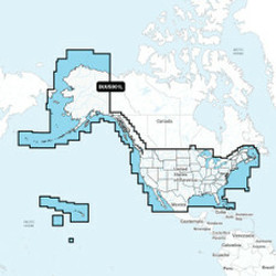
![Garmin Navionics+ NSUS001L US Coastal Canada [010-C1287-20]](https://cdn11.bigcommerce.com/s-ge8sirtax0/images/stencil/230x230/products/25659/33713/92669XL__67631.1678016380.jpg?c=1 "Garmin Navionics+ NSUS001L US Coastal Canada [010-C1287-20]")
Garmin
Garmin Navionics+ NSUS001L US Coastal Canada [010-C1287-20]
$199.99
Navionics+ NSUS001L US & Coastal CanadaGet the world’s No. 1 choice in the marine mapping (based on 2020 reported sales) — with the best, most up-to-date Navionics®+ cartography on your compatible chartplotter. For offshore or inland...
![Navionics+ NAUS008R - U.S. West [010-C1371-30]](https://cdn11.bigcommerce.com/s-ge8sirtax0/images/stencil/230x230/products/25612/33608/92610XL__41431.1678016227.jpg?c=1 "Navionics+ NAUS008R - U.S. West [010-C1371-30]")
Navionics
Navionics NAUS008R - U.S. West - Navionics+ [010-C1371-30]
$149.99
NAUS008R - U.S. West - Navionics+Get the world’s No. 1 choice in marine mapping - with the best, most up-to-date Navionics+ cartography on your compatible chartplotter. For offshore or inland waters, this all-in-one solution offers...
![Navionics+ NAUS007R - U.S. East [010-C1370-30]](https://cdn11.bigcommerce.com/s-ge8sirtax0/images/stencil/230x230/products/25611/33607/92609XL__34329.1678016225.jpg?c=1 "Navionics+ NAUS007R - U.S. East [010-C1370-30]")
Navionics
Navionics NAUS007R - U.S. East - Navionics+ [010-C1370-30]
$149.99
NAUS007R - U.S. East - Navionics+Get the world’s No. 1 choice in marine mapping - with the best, most up-to-date Navionics+ cartography on your compatible chartplotter. For offshore or inland waters, this all-in-one solution offers...
![Navionics+ NAUS006R - U.S. South [010-C1369-30]](https://cdn11.bigcommerce.com/s-ge8sirtax0/images/stencil/230x230/products/25610/33606/92608XL__82069.1678016222.jpg?c=1 "Navionics+ NAUS006R - U.S. South [010-C1369-30]")
Navionics
Navionics NAUS006R - U.S. South - Navionics+ [010-C1369-30]
$149.99
NAUS006R - U.S. South - Navionics+Get the world’s No. 1 choice in marine mapping - with the best, most up-to-date Navionics+ cartography on your compatible chartplotter. For offshore or inland waters, this all-in-one solution offers...
![Navionics+ NAUS005R - U.S. North [010-C1368-30]](https://cdn11.bigcommerce.com/s-ge8sirtax0/images/stencil/230x230/products/25609/33605/92607XL__37572.1678016220.jpg?c=1 "Navionics+ NAUS005R - U.S. North [010-C1368-30]")
Navionics
Navionics NAUS005R - U.S. North - Navionics+ [010-C1368-30]
$149.99
NAUS005R - U.S. North - Navionics+Get the world’s No. 1 choice in marine mapping - with the best, most up-to-date Navionics+ cartography on your compatible chartplotter. For offshore or inland waters, this all-in-one solution offers...
![Navionics+ NAUS001L - U.S. Coastal Canada [010-C1366-30]](https://cdn11.bigcommerce.com/s-ge8sirtax0/images/stencil/230x230/products/25607/33603/92605XL__65621.1678016214.jpg?c=1 "Navionics+ NAUS001L - U.S. Coastal Canada [010-C1366-30]")
Navionics
Navionics NAUS001L - U.S. Coastal Canada - Navionics+ [010-C1366-30]
$199.99
NAUS001L - U.S. & Coastal Canada - Navionics+Get the world’s No. 1 choice in marine mapping - with the best, most up-to-date Navionics+ cartography on your compatible chartplotter. For offshore or inland waters, this all-in-one solution...
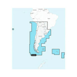
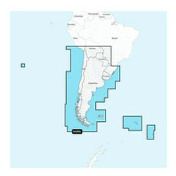
![Navionics+ NASA005L - Chile, Argentina Easter Island [010-C1365-30]](https://cdn11.bigcommerce.com/s-ge8sirtax0/images/stencil/230x230/products/25606/33602/92604XL__39377.1678016211.jpg?c=1 "Navionics+ NASA005L - Chile, Argentina Easter Island [010-C1365-30]")
Navionics
Navionics NASA005L - Chile, Argentina Easter Island - Navionics+ [010-C1365-30]
$199.99
NASA005L - Chile, Argentina & Easter Island - Navionics+Get the world’s No. 1 choice in marine mapping - with the best, most up-to-date Navionics+ cartography on your compatible chartplotter. For offshore or inland waters, this all-in-one...
![Navionics+ NASA004L - Mexico, Caribbean to Brazil [010-C1364-30]](https://cdn11.bigcommerce.com/s-ge8sirtax0/images/stencil/230x230/products/25605/33601/92603XL__47702.1678016209.jpg?c=1 "Navionics+ NASA004L - Mexico, Caribbean to Brazil [010-C1364-30]")
Navionics
Navionics NASA004L - Mexico, Caribbean to Brazil - Navionics+ [010-C1364-30]
$199.99
NASA004L - Mexico, Caribbean to Brazil - Navionics+ Get the world’s No. 1 choice in marine mapping - with the best, most up-to-date Navionics+ cartography on your compatible chartplotter. For offshore or inland waters, this all-in-one...
![C-MAP M-NA-Y214-MS US Lakes South East REVEAL Inland Chart [M-NA-Y214-MS]](https://cdn11.bigcommerce.com/s-ge8sirtax0/images/stencil/230x230/products/22532/29179/87979XL__96314.1678008167.jpg?c=1 "C-MAP M-NA-Y214-MS US Lakes South East REVEAL Inland Chart [M-NA-Y214-MS]")
C-MAP
C-MAP M-NA-Y214-MS US Lakes South East REVEAL Inland Chart [M-NA-Y214-MS]
$199.00
M-NA-Y214-MS US Lakes South East REVEAL™ Inland ChartWhether cruising or fishing or C-MAP® REVEAL™ Lakes charts offer the very best of C-MAP. With Shaded Relief, including Reveal Seafloor, Aerial Photography and Satellite Overlay...
![C-MAP M-NA-Y216-MS Canada Lakes REVEAL Inland Chart [M-NA-Y216-MS]](https://cdn11.bigcommerce.com/s-ge8sirtax0/images/stencil/230x230/products/22289/28871/87550XL__92850.1678007557.jpg?c=1 "C-MAP M-NA-Y216-MS Canada Lakes REVEAL Inland Chart [M-NA-Y216-MS]")
C-MAP
C-MAP M-NA-Y216-MS Canada Lakes REVEAL Inland Chart [M-NA-Y216-MS]
$199.00
M-NA-Y216-MS Canada Lakes REVEAL™ Inland ChartWhether cruising or fishing or C-MAP® REVEAL™ Lakes charts offer the very best of C-MAP. With Shaded Relief, including Reveal Seafloor, Aerial Photography and Satellite Overlay presentation...
![C-MAP M-NA-Y215-MS US Lakes South Central REVEAL Inland Chart [M-NA-Y215-MS]](https://cdn11.bigcommerce.com/s-ge8sirtax0/images/stencil/230x230/products/22288/28870/87549XL__56035.1678007555.jpg?c=1 "C-MAP M-NA-Y215-MS US Lakes South Central REVEAL Inland Chart [M-NA-Y215-MS]")
C-MAP
C-MAP M-NA-Y215-MS US Lakes South Central REVEAL Inland Chart [M-NA-Y215-MS]
$179.00
M-NA-Y215-MS US Lakes South Central REVEAL™ Inland ChartWhether cruising or fishing or C-MAP® REVEAL™ Lakes charts offer the very best of C-MAP. With Shaded Relief, including Reveal Seafloor, Aerial Photography and Satellite Overlay...
![C-MAP M-NA-Y213-MS US Lakes East REVEAL Inland Chart [M-NA-Y213-MS]](https://cdn11.bigcommerce.com/s-ge8sirtax0/images/stencil/230x230/products/22287/28869/87548XL__23029.1678007553.jpg?c=1 "C-MAP M-NA-Y213-MS US Lakes East REVEAL Inland Chart [M-NA-Y213-MS]")
C-MAP
C-MAP M-NA-Y213-MS US Lakes East REVEAL Inland Chart [M-NA-Y213-MS]
$179.00
M-NA-Y213-MS US Lakes East REVEAL™ Inland ChartWhether cruising or fishing or C-MAP® REVEAL™ Lakes charts offer the very best of C-MAP. With Shaded Relief, including Reveal Seafloor, Aerial Photography and Satellite Overlay presentation...