 US Dollars
Cartography
Sub Categories

![Navionics+ NAUS005R - U.S. North [010-C1368-30]](https://cdn11.bigcommerce.com/s-ge8sirtax0/images/stencil/230x230/products/25609/33605/92607XL__37572.1678016220.jpg?c=1 "Navionics+ NAUS005R - U.S. North [010-C1368-30]")
Navionics
Navionics NAUS005R - U.S. North - Navionics+ [010-C1368-30]
$149.99
NAUS005R - U.S. North - Navionics+Get the world’s No. 1 choice in marine mapping - with the best, most up-to-date Navionics+ cartography on your compatible chartplotter. For offshore or inland waters, this all-in-one solution offers...
![Navionics+ NAUS001L - U.S. Coastal Canada [010-C1366-30]](https://cdn11.bigcommerce.com/s-ge8sirtax0/images/stencil/230x230/products/25607/33603/92605XL__65621.1678016214.jpg?c=1 "Navionics+ NAUS001L - U.S. Coastal Canada [010-C1366-30]")
Navionics
Navionics NAUS001L - U.S. Coastal Canada - Navionics+ [010-C1366-30]
$199.99
NAUS001L - U.S. & Coastal Canada - Navionics+Get the world’s No. 1 choice in marine mapping - with the best, most up-to-date Navionics+ cartography on your compatible chartplotter. For offshore or inland waters, this all-in-one solution...
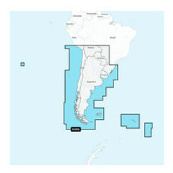
![Navionics+ NASA005L - Chile, Argentina Easter Island [010-C1365-30]](https://cdn11.bigcommerce.com/s-ge8sirtax0/images/stencil/230x230/products/25606/33602/92604XL__39377.1678016211.jpg?c=1 "Navionics+ NASA005L - Chile, Argentina Easter Island [010-C1365-30]")
Navionics
Navionics NASA005L - Chile, Argentina Easter Island - Navionics+ [010-C1365-30]
$199.99
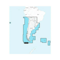
NASA005L - Chile, Argentina & Easter Island - Navionics+Get the world’s No. 1 choice in marine mapping - with the best, most up-to-date Navionics+ cartography on your compatible chartplotter. For offshore or inland waters, this all-in-one...
![Navionics+ NASA004L - Mexico, Caribbean to Brazil [010-C1364-30]](https://cdn11.bigcommerce.com/s-ge8sirtax0/images/stencil/230x230/products/25605/33601/92603XL__47702.1678016209.jpg?c=1 "Navionics+ NASA004L - Mexico, Caribbean to Brazil [010-C1364-30]")
Navionics
Navionics NASA004L - Mexico, Caribbean to Brazil - Navionics+ [010-C1364-30]
$199.99
NASA004L - Mexico, Caribbean to Brazil - Navionics+ Get the world’s No. 1 choice in marine mapping - with the best, most up-to-date Navionics+ cartography on your compatible chartplotter. For offshore or inland waters, this all-in-one...
![C-MAP REVEAL Chart - South America - East Coast [M-SA-Y501-MS]](https://cdn11.bigcommerce.com/s-ge8sirtax0/images/stencil/230x230/products/23778/30863/89914XL__70598.1678011407.jpg?c=1 "C-MAP REVEAL Chart - South America - East Coast [M-SA-Y501-MS]")
C-MAP
C-MAP REVEAL Chart - South America - East Coast [M-SA-Y501-MS]
$249.90
REVEAL™ Chart - South America - East CoastThe premium mapping solution for cruisers, anglers, and sailors looking for accurate, quality data with game-changing shaded relief from the market leader.Cruising, fishing, or sailing, C-MAP®...
![Humminbird CoastMaster Premium Edition - Florida - Version 1 [602014-1]](https://cdn11.bigcommerce.com/s-ge8sirtax0/images/stencil/230x230/products/23021/29720/88682XL__88101.1678009300.jpg?c=1 "Humminbird CoastMaster Premium Edition - Florida - Version 1 [602014-1]")
Humminbird
Humminbird CoastMaster Premium Edition - Florida - Version 1 [602014-1]
$299.99
CoastMaster™ Premium Edition - Florida - Version 1CoastMaster Premium, Florida arms saltwater anglers with even more information to identify the most productive areas in all Florida coastal waters.Premium Features:2D Shaded Relief makes bottom...
![C-MAP M-NA-Y214-MS US Lakes South East REVEAL Inland Chart [M-NA-Y214-MS]](https://cdn11.bigcommerce.com/s-ge8sirtax0/images/stencil/230x230/products/22532/29179/87979XL__96314.1678008167.jpg?c=1 "C-MAP M-NA-Y214-MS US Lakes South East REVEAL Inland Chart [M-NA-Y214-MS]")
C-MAP
C-MAP M-NA-Y214-MS US Lakes South East REVEAL Inland Chart [M-NA-Y214-MS]
$169.90
M-NA-Y214-MS US Lakes South East REVEAL™ Inland ChartWhether cruising or fishing or C-MAP® REVEAL™ Lakes charts offer the very best of C-MAP. With Shaded Relief, including Reveal Seafloor, Aerial Photography and Satellite Overlay...
![C-MAP M-NA-Y216-MS Canada Lakes REVEAL Inland Chart [M-NA-Y216-MS]](https://cdn11.bigcommerce.com/s-ge8sirtax0/images/stencil/230x230/products/22289/28871/87550XL__92850.1678007557.jpg?c=1 "C-MAP M-NA-Y216-MS Canada Lakes REVEAL Inland Chart [M-NA-Y216-MS]")
C-MAP
C-MAP M-NA-Y216-MS Canada Lakes REVEAL Inland Chart [M-NA-Y216-MS]
$169.90
M-NA-Y216-MS Canada Lakes REVEAL™ Inland ChartWhether cruising or fishing or C-MAP® REVEAL™ Lakes charts offer the very best of C-MAP. With Shaded Relief, including Reveal Seafloor, Aerial Photography and Satellite Overlay presentation...
![C-MAP M-NA-Y215-MS US Lakes South Central REVEAL Inland Chart [M-NA-Y215-MS]](https://cdn11.bigcommerce.com/s-ge8sirtax0/images/stencil/230x230/products/22288/28870/87549XL__56035.1678007555.jpg?c=1 "C-MAP M-NA-Y215-MS US Lakes South Central REVEAL Inland Chart [M-NA-Y215-MS]")
C-MAP
C-MAP M-NA-Y215-MS US Lakes South Central REVEAL Inland Chart [M-NA-Y215-MS]
$169.90
M-NA-Y215-MS US Lakes South Central REVEAL™ Inland ChartWhether cruising or fishing or C-MAP® REVEAL™ Lakes charts offer the very best of C-MAP. With Shaded Relief, including Reveal Seafloor, Aerial Photography and Satellite Overlay...
![C-MAP M-NA-Y213-MS US Lakes East REVEAL Inland Chart [M-NA-Y213-MS]](https://cdn11.bigcommerce.com/s-ge8sirtax0/images/stencil/230x230/products/22287/28869/87548XL__23029.1678007553.jpg?c=1 "C-MAP M-NA-Y213-MS US Lakes East REVEAL Inland Chart [M-NA-Y213-MS]")
C-MAP
C-MAP M-NA-Y213-MS US Lakes East REVEAL Inland Chart [M-NA-Y213-MS]
$169.90
M-NA-Y213-MS US Lakes East REVEAL™ Inland ChartWhether cruising or fishing or C-MAP® REVEAL™ Lakes charts offer the very best of C-MAP. With Shaded Relief, including Reveal Seafloor, Aerial Photography and Satellite Overlay presentation...
![C-MAP M-NA-Y212-MS US Lakes North Central REVEAL Inland Chart [M-NA-Y212-MS]](https://cdn11.bigcommerce.com/s-ge8sirtax0/images/stencil/230x230/products/22286/28868/87547XL__59882.1678007551.jpg?c=1 "C-MAP M-NA-Y212-MS US Lakes North Central REVEAL Inland Chart [M-NA-Y212-MS]")
C-MAP
C-MAP M-NA-Y212-MS US Lakes North Central REVEAL Inland Chart [M-NA-Y212-MS]
$169.90
M-NA-Y212-MS US Lakes North Central REVEAL™ Inland ChartWhether cruising or fishing or C-MAP® REVEAL™ Lakes charts offer the very best of C-MAP. With Shaded Relief, including Reveal Seafloor, Aerial Photography and Satellite Overlay...
![C-MAP M-NA-Y211-MS US Lakes West REVEAL Inland Chart [M-NA-Y211-MS]](https://cdn11.bigcommerce.com/s-ge8sirtax0/images/stencil/230x230/products/22285/28867/87546XL__16469.1678007548.jpg?c=1 "C-MAP M-NA-Y211-MS US Lakes West REVEAL Inland Chart [M-NA-Y211-MS]")
C-MAP
C-MAP M-NA-Y211-MS US Lakes West REVEAL Inland Chart [M-NA-Y211-MS]
$169.90
M-NA-Y211-MS US Lakes West REVEAL™ Inland ChartWhether cruising or fishing or C-MAP® REVEAL™ Lakes charts offer the very best of C-MAP. With Shaded Relief, including Reveal Seafloor, Aerial Photography and Satellite Overlay presentation...
![C-MAP M-NA-Y210-MS Hawaii Marshall Islands French Polynesia REVEAL Coastal Chart [M-NA-Y210-MS]](https://cdn11.bigcommerce.com/s-ge8sirtax0/images/stencil/230x230/products/22284/28866/87545XL__61830.1678007546.jpg?c=1 "C-MAP M-NA-Y210-MS Hawaii Marshall Islands French Polynesia REVEAL Coastal Chart [M-NA-Y210-MS]")
C-MAP
C-MAP M-NA-Y210-MS Hawaii Marshall Islands French Polynesia REVEAL Coastal Chart [M-NA-Y210-MS]
$249.90
M-NA-Y210-MS Hawaii Marshall Islands French Polynesia REVEAL™ Coastal ChartWhether cruising or fishing, C-MAP REVEAL™ Coastal charts offer the very best of C-MAP. With Shaded Relief, including Reveal Seafloor, Aerial Photography, Satellite...
![C-MAP M-NA-Y209-MS Canada North East REVEAL Coastal Chart [M-NA-Y209-MS]](https://cdn11.bigcommerce.com/s-ge8sirtax0/images/stencil/230x230/products/22282/28864/87533XL__16844.1678007540.jpg?c=1 "C-MAP M-NA-Y209-MS Canada North East REVEAL Coastal Chart [M-NA-Y209-MS]")
C-MAP
C-MAP M-NA-Y209-MS Canada North East REVEAL Coastal Chart [M-NA-Y209-MS]
$249.90
M-NA-Y209-MS Canada North & East REVEAL™ Coastal ChartWhether cruising or fishing, C-MAP REVEAL™ Coastal charts offer the very best of C-MAP. With Shaded Relief, including Reveal Seafloor, Aerial Photography, Satellite Overlay and...
![C-MAP M-NA-Y208-MS Alaska REVEAL Coastal Chart [M-NA-Y208-MS]](https://cdn11.bigcommerce.com/s-ge8sirtax0/images/stencil/230x230/products/22281/28863/87532XL__90789.1678007538.jpg?c=1 "C-MAP M-NA-Y208-MS Alaska REVEAL Coastal Chart [M-NA-Y208-MS]")
C-MAP
C-MAP M-NA-Y208-MS Alaska REVEAL Coastal Chart [M-NA-Y208-MS]
$249.90
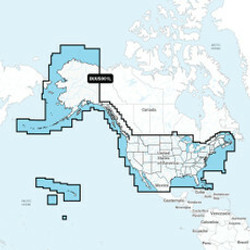
M-NA-Y208-MS Alaska REVEAL™ Coastal ChartWhether cruising or fishing, C-MAP REVEAL™ Coastal charts offer the very best of C-MAP. With Shaded Relief, including Reveal Seafloor, Aerial Photography, Satellite Overlay and Dynamic Raster Chart...
![C-MAP M-NA-Y207-MS Columbia Puget Sound REVEAL Coastal Chart [M-NA-Y207-MS]](https://cdn11.bigcommerce.com/s-ge8sirtax0/images/stencil/230x230/products/22280/28862/87531XL__34709.1678007536.jpg?c=1 "C-MAP M-NA-Y207-MS Columbia Puget Sound REVEAL Coastal Chart [M-NA-Y207-MS]")
C-MAP
C-MAP M-NA-Y207-MS Columbia Puget Sound REVEAL Coastal Chart [M-NA-Y207-MS]
$249.90
M-NA-Y207-MS Columbia & Puget Sound REVEAL™ Coastal ChartWhether cruising or fishing, C-MAP® REVEAL™ Coastal charts offer the very best of C-MAP. With Shaded Relief, including Reveal Seafloor, Aerial Photography, Satellite Overlay,...
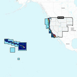
![C-MAP M-NA-Y206-MS West Coast Baja California REVEAL Coastal Chart - Does NOT contain Hawaii [M-NA-Y206-MS]](https://cdn11.bigcommerce.com/s-ge8sirtax0/images/stencil/230x230/products/22279/28861/87530XL__86953.1678007533.jpg?c=1 "C-MAP M-NA-Y206-MS West Coast Baja California REVEAL Coastal Chart - Does NOT contain Hawaii [M-NA-Y206-MS]")
C-MAP
C-MAP M-NA-Y206-MS West Coast Baja California REVEAL Coastal Chart - Does NOT contain Hawaii [M-NA-Y206-MS]
$249.90
M-NA-Y206-MS West Coast & Baja California REVEAL™ Coastal Chart - Does NOT contain HawaiiWhether cruising or fishing, C-MAP REVEAL™ Coastal charts offer the very best of C-MAP. With Shaded Relief, including Reveal Seafloor, Aerial...
![C-MAP M-NA-Y205-MS Central America Caribbean REVEAL Coastal Chart [M-NA-Y205-MS]](https://cdn11.bigcommerce.com/s-ge8sirtax0/images/stencil/230x230/products/22278/28860/87529XL__81501.1678007531.jpg?c=1 "C-MAP M-NA-Y205-MS Central America Caribbean REVEAL Coastal Chart [M-NA-Y205-MS]")
C-MAP
C-MAP M-NA-Y205-MS Central America Caribbean REVEAL Coastal Chart [M-NA-Y205-MS]
$249.90
M-NA-Y205-MS Central America & Caribbean REVEAL™ Coastal ChartWhether cruising or fishing, C-MAP REVEAL™ Coastal charts offer the very best of C-MAP. With Shaded Relief, including Reveal Seafloor, Aerial Photography, Satellite Overlay...
![C-MAP M-NA-Y204-MS Gulf of Mexico to Bahamas REVEAL Coastal Chart [M-NA-Y204-MS]](https://cdn11.bigcommerce.com/s-ge8sirtax0/images/stencil/230x230/products/22277/28859/87528XL__56505.1678007529.jpg?c=1 "C-MAP M-NA-Y204-MS Gulf of Mexico to Bahamas REVEAL Coastal Chart [M-NA-Y204-MS]")
C-MAP
C-MAP M-NA-Y204-MS Gulf of Mexico to Bahamas REVEAL Coastal Chart [M-NA-Y204-MS]
$249.90
M-NA-Y204-MS Gulf of Mexico to Bahamas REVEAL™ Coastal ChartWhether cruising or fishing, C-MAP REVEAL™ Coastal charts offer the very best of C-MAP. With Shaded Relief, including Reveal Seafloor, Aerial Photography, Satellite Overlay and...
![C-MAP M-NA-Y203-MS Chesapeake Bay to Bahamas REVEAL Coastal Chart [M-NA-Y203-MS]](https://cdn11.bigcommerce.com/s-ge8sirtax0/images/stencil/230x230/products/22276/28858/87527XL__13764.1678007527.jpg?c=1 "C-MAP M-NA-Y203-MS Chesapeake Bay to Bahamas REVEAL Coastal Chart [M-NA-Y203-MS]")
C-MAP
C-MAP M-NA-Y203-MS Chesapeake Bay to Bahamas REVEAL Coastal Chart [M-NA-Y203-MS]
$249.90
M-NA-Y203-MS Chesapeake Bay to Bahamas REVEAL™ Coastal ChartWhether cruising or fishing, C-MAP REVEAL™ Coastal charts offer the very best of C-MAP. With Shaded Relief, including Reveal Seafloor, Aerial Photography, Satellite Overlay and...