 US Dollars
Cartography
Sub Categories

![C-MAP MAX NA-M027 - Central America & The Caribbean - C-Card [NA-M027C-CARD]](https://cdn11.bigcommerce.com/s-ge8sirtax0/images/stencil/230x230/products/1472/1928/30131XL__92247.1677873110.jpg?c=1 "C-MAP MAX NA-M027 - Central America & The Caribbean - C-Card [NA-M027C-CARD]")
C-MAP
C-MAP MAX NA-M027 - Central America & The Caribbean - C-Card [NA-M027C-CARD]
$279.00
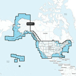
NA-M027 => Central America and CaribbeanCoverage of Central America, all of the Caribbean and the northern coast of South America, and the Gulf of Mexico. Coverage of the Pacific coast starts at Point Conception, CA and runs down to Bahia Cupica,...
![C-Map NA-M420 Gulf of Mexico Bathy Chart - C-Card [NA-M420C-CARD]](https://cdn11.bigcommerce.com/s-ge8sirtax0/images/stencil/230x230/products/1175/1622/28216XL__23776.1677872216.jpg?c=1 "C-Map NA-M420 Gulf of Mexico Bathy Chart - C-Card [NA-M420C-CARD]")
C-MAP
C-Map NA-M420 Gulf of Mexico Bathy Chart - C-Card [NA-M420C-CARD]
$279.00
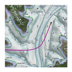
NA-M420 Gulf of Mexico Bathy Chart - C-CardGulf of Mexico coverage includes the offshore bathymetric details for the Gulf of Mexico from Key West, FL over and around to Brownsville, TX. Additional coverage up the eastern coast of Florida to Jacksonville...
![C-MAP MAX SA-M500 - Costa Rica-Chile-Falklands - C-Card [SA-M500C-CARD]](https://cdn11.bigcommerce.com/s-ge8sirtax0/images/stencil/230x230/products/633/974/18919XL__03527.1677870453.jpg?c=1 "C-MAP MAX SA-M500 - Costa Rica-Chile-Falklands - C-Card [SA-M500C-CARD]")
C-MAP
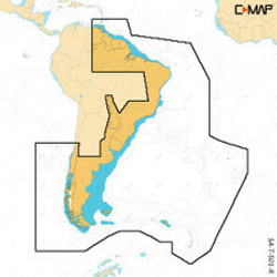
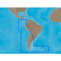
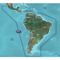
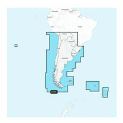
C-MAP MAX SA-M500 - Costa Rica-Chile-Falklands - C-Card [SA-M500C-CARD]
$279.00
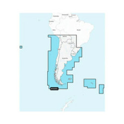
SA-M500 => Costa Rica to Chile to FalklandsCoverage starts at Bahia de Salinas on Costa Rica's Pacific coast, and extends south and east along the coasts of Panama, Colombia, Ecuador, Peru and Chile, wrapping around Cape Horn and back up along the...
![C-MAP MAX SA-M501 - Gulf of Paria - Cape Horn - SD Card [SA-M501SDCARD]](https://cdn11.bigcommerce.com/s-ge8sirtax0/images/stencil/230x230/products/631/972/17594XL__21524.1677870446.jpg?c=1 "C-MAP MAX SA-M501 - Gulf of Paria - Cape Horn - SD Card [SA-M501SDCARD]")
C-MAP
C-MAP MAX SA-M501 - Gulf of Paria - Cape Horn - SD Card [SA-M501SDCARD]
$279.00
SA-M501 => Gulf of Paria to Cape HornCoverage starts at Quintero, Chile on the Pacific coast and extends south down the Chile border, wraps up around Cape Horn and continues up the Atlantic coasts of Argentina, Uruguay, Brazil, French Guiana, Suriname,...
![C-MAP MAX SA-M500 - Costa Rica-Chile Falklands - SD Card [SA-M500SDCARD]](https://cdn11.bigcommerce.com/s-ge8sirtax0/images/stencil/230x230/products/630/971/17593XL__92347.1677870443.jpg?c=1 "C-MAP MAX SA-M500 - Costa Rica-Chile Falklands - SD Card [SA-M500SDCARD]")
C-MAP
C-MAP MAX SA-M500 - Costa Rica-Chile Falklands - SD Card [SA-M500SDCARD]
$279.00
SA-M500 => Costa Rica to Chile to FalklandsCoverage starts at Bahia de Salinas on Costa Rica's Pacific coast, and extends south and east along the coasts of Panama, Colombia, Ecuador, Peru and Chile, wrapping around Cape Horn and back up along the...